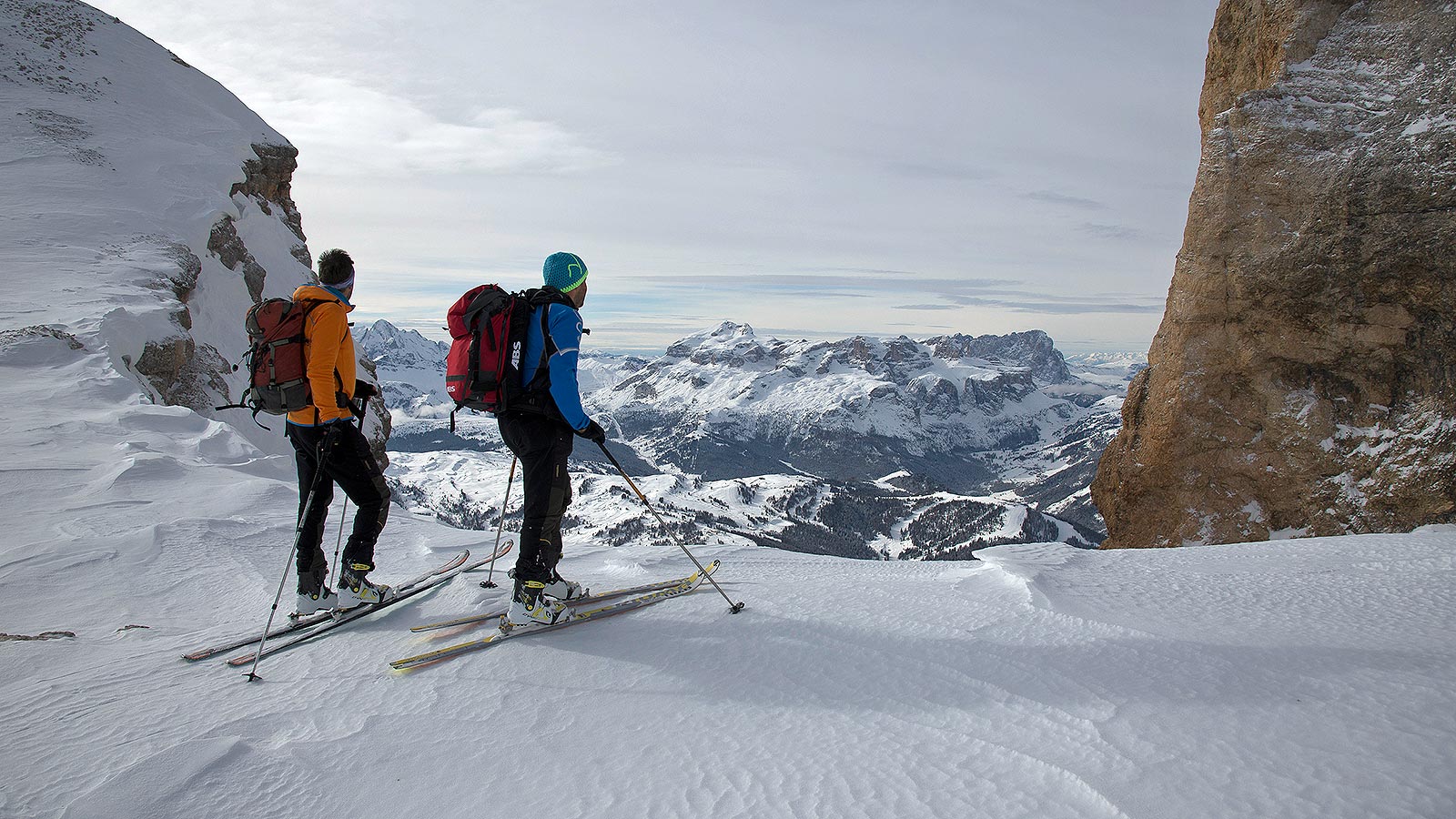
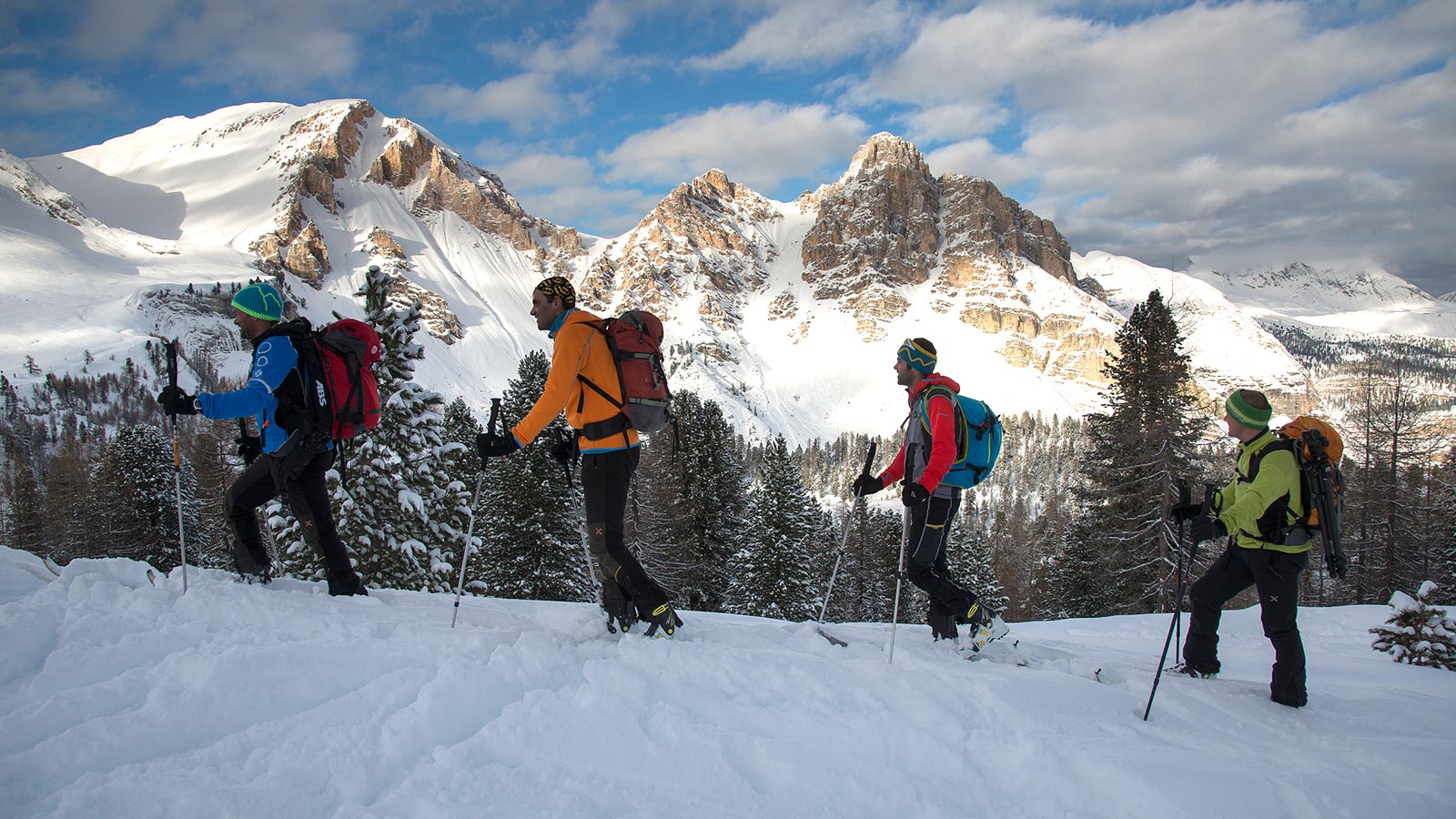
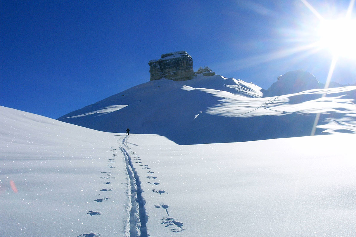
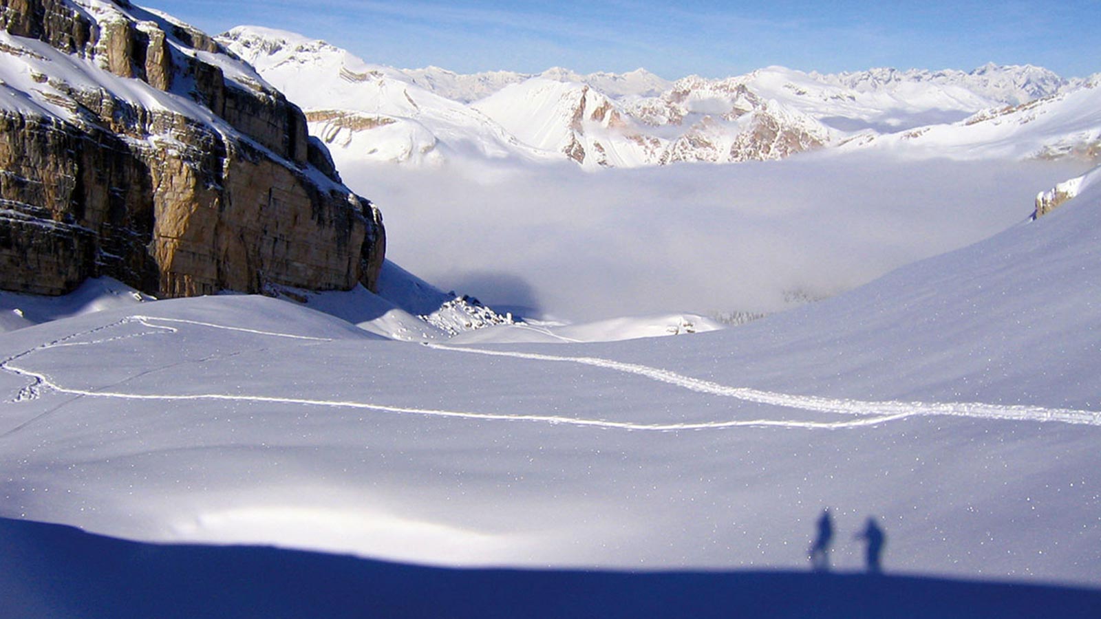
Alpine skiing in Fanes Sennes Braies natural park
The nearest cable cars are located in S. Vigilio 18 km from the Fanes hut. They are connected to the Plan de Corones skiing resort outside the Fanes - Senes - Braies Natural Park.
Warning! Some of the excursions require an adequate preparation, equipment and/or an expert guide because they're dangerous!
If you want to have the indications with you in the next excursions, click here, print the document e put it in your backpack.
The proposals for alpine skiing excursions are taken form the book "FANES - Wandern durch Geschichte und Landschaft" (FANES - Hiking through history and landscape) from Peter Kübler and have been translated.
AVALANCHE REPORT
on the web: www.provinz.bz.it/valanghe (in German or Italian)
via WAP: wap.provinz.bz.it
via Self-fax: +39 0471 270555 - +39 0471 271177
by phone: +39 0471 270555 - +39 0471 271177
Download all Tours
Easy
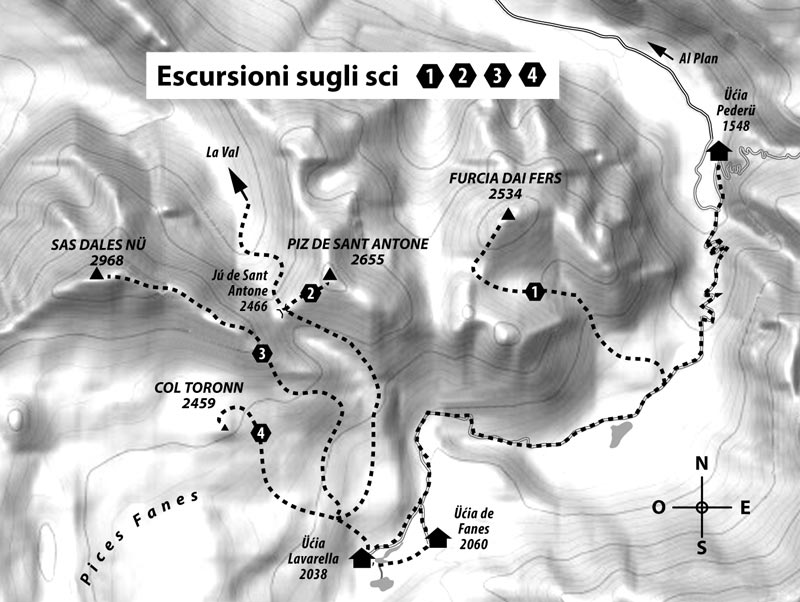
Tour 1: FURCIA DAI FERS – 2534 m
Tour 1: FURCIA DAI FERS – 2534 m
From Lé Piciodel northwards in the upper valley shaped like a funnel between northern and southern Furcia dai Fers. Keep left (west) to reach the pass between the two peaks of Furcia dai Fers. Then head north along the ridge. Ski storage just below the summit on a rocky cliff.
Duration: from 1½ to 2½ • Difference in altitude: around 700 m
From Pederü: around 990 m • Duration 3-4 hours.
Note: Partially steep excursion for expert mountaineers. For the climb to the summit crampons are recommend depending on the circumstances. It is possible to reach more summits starting from the pass.
Easy
Tour 2: PIZ DE SANT ANTONE – 2655 m
Tour 2: PIZ DE SANT ANTONE – 2655 m
From the Fanes Mountain Hut follow the summer path number 13, cross through Plan de Sarënes up to Ju de Sant Antone (2466 m), along the western ridge up to the summit.
Duration: 2-3 hours • Difference in altitude: around 620 m
Note: Partially steep excursion for expert mountaineers. The climb to the summit is recommended on foot; depending on the conditions crampons are recommended.
Depending on the snow conditions descent is by the steep side or along the path of the ascent.
From the summit of Sant Antone more expert skiers can descend directly to Rudo Valley (beware of steep slopes) and ascend other summits such as Furcia dai Fers. These possibilities depend heavily on snow conditions and should only be taken into consideration only when visibility is good.
Easy
Tour 3: SAS DLES NÖ – 2968 m also »Cima Nove«
Tour 3: SAS DLES NÖ – 2968 m also »Cima Nove«
From the Fanes Mountain Hut northwards up to the Pices Fanes meadow. The southern slope of Sas Dles Nöcan can be reached from the west (under Col Toronn) and the east (on the summer path number 13 to Ju de Sant Antone). Along the steep ridge that leads to the smaller peak (2874 m, a destination for the majority of people who do ski-mountaineering). The main summit (2968 m) can be reached via the sharp east ridge which is larger closer to the summit. The ridge requires sure-footedness and a good head for heights; to be tackled only in good weather conditions.
Duration: up to the smaller peak from 2 to 3 hours • Difference in altitude: around 830 m
Note: A steep tour. Requires settled snow . Warning at the end of winter when the snow is warmed by the sun.
Easy
Tour 4: COL TORONN – 2459 m – also: »Tartaruga«
Tour 4: COL TORONN – 2459 m – also: »Tartaruga«
From the Fanes Mountain Hut northwards for around 150 m, up to the Pices Fanes meadow. Then continue in a north-western direction up to the foot of the mountain that can be climbed from left or right. The last few metres up to the summit from the north can only be done on foot.
Duration: from 1 to 2 hours • Difference in altitude: around 420 m
Note: An easy tour. If you choose the route carefully there is a low avalanche risk.
Easy
Tour 5: CIASTEL DE FANES – 2657 m – also »Castello di Fanes«
Tour 5: CIASTEL DE FANES – 2657 m – also »Castello di Fanes«
Like Tour 4 , continue on the Pices Fanes meadow. Continue in a north-westerly direction in a flat alpine valley until you see the double summit of Ciastel de Fanes. Then go towards them and go around them from the left (west), up to the pass (2608 m). From there – depending on the snow conditions– you can easily reach the summit on skis or on foot.
Duration: Ascent from 1½ to 2½ hours • Difference in altitude: around 620 m
Note: An easy excursion.
Easy
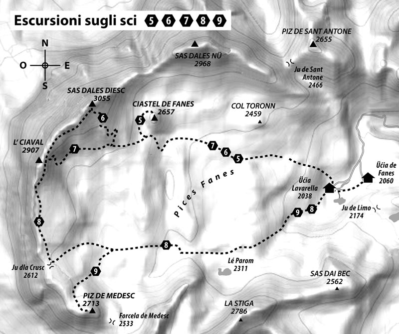
Tour 6: SAS DLES DIESC – 3026 m – also »Cima Dieci«
Tour 6: SAS DLES DIESC – 3026 m – also »Cima Dieci«
Like Tour 4, ascend to the Pices Fanes meadow and continue to the flat upper valley in a north-western direction until you see the double summit of Mount Castello. Continue to the foot of the mountain, then head north-west towards the southern slope of Sas dles Diesc. Climb on the side keeping left up to the steep structure at the end (ski storage).
Duration: Ascent from 3 to 5 hours • Difference in altitude: around 1000 m
Note: With poor visibility orientation is difficult. The descent is the same as the ascent. Requires settled snow . Warning at the end of winter when the snow is warmed by the sun.
(leave on time!)
The summit cab reached by following the metal wire. Moderately difficult if uncovered otherwise a more demanding mountaineering pass is required.
Easy
Tour 7: L‘CIAVAL – 2907 m – also »Sasso della Croce«
Tour 7: L‘CIAVAL – 2907 m – also »Sasso della Croce«
Like Tour 6, up to the larges stones under the southern flank of Sas Ddes Diesc. Cross the blocks (2594 m), but in a western direction up to the eastern flank of Le Ciaval and then climb to the summit.
Duration: Ascent 3-5 hours • Difference in altitude: around 900 m
Note: With poor visibility orientation is difficult. Requires settled snow.
Easy
Tour 8: L‘CIAVAL – 2907 m • Variant
Tour 8: L‘CIAVAL – 2907 m • Variant
From the Fanes Mountain Hut towards the valley that rises to the southwest. There on the valley floor or the right flank continue near summer path number 12 that leads to a wide opening with Lé Parom. Continue to the west up to 2370 m (here in the summer paths numbers 7 and 12 meet). From here continue westwards up to Ju dla Crusc (Forcella del Sasso Croce 2609 m). On the large ridge (beware of snow cornices) to the north up to the ski storage under the summit up to the peak.
Duration: from 3½ to 5 hours • Difference in altitude: around 900 m
Note: Not a difficult tour, that does require resistance. With poor visibility orientation is difficult.
Easy
Tour 9: PIZ DE MEDESC – 2713 m
Tour 9: PIZ DE MEDESC – 2713 m
From the Fanes Mountain Hut continue like Tour 8 towards Pices Fanes meadow up to the valley at 2370 m (here in the summer paths numbers 7 and 12 meet). From here continue westwards until it is possible to turn south and then head north until Piz de Medesc. From here you can reach the summit. Descent is the same as the ascent.
Duration: 3-4 hours • Difference in altitude: around 700 m
Easy
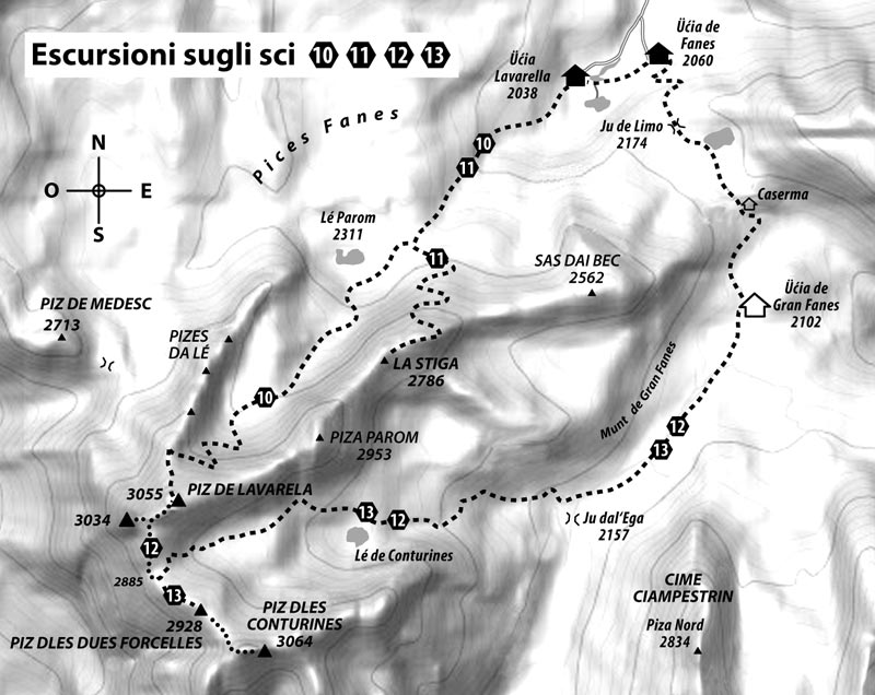
Tour 10: PIZ DE LAVARELA – 3055 m – from the north – also »Monte Lavarella«
Tour 10: PIZ DE LAVARELA – 3055 m – from the north – also »Monte Lavarella«
From the Fanes Mountain Hut towards the valley that rises to the southwest. There on the valley floor or on the right flank continue near summer path number 12 that leads to Lé Parom. Then head south-westwards in Val Parom and from here you start to climb. Finally keep right along the rather steep path in the pass between the north ridge of Piz de Lavarela and Pizes de Lé. From there first on the exposed north ridge and then on the open north flank of the mountain (beware of: snow accumulations caused by the wind) on the summit.
Duration: 4-5 hours • Difference in altitude: around 1000 m
Note: In the highest part of Val Parom and on the northern flank the path is probably exposed to avalanches caused by snow accumulations caused by the wind. Descent is the same as the ascent or to the south passing through Büsc da Stlü (see Tour 12).
Easy
Tour 11: PIZ STIGA – 2776 m
Tour 11: PIZ STIGA – 2776 m
From the Fanes Mountain Hut up to Ju de Limo and then right (south-west), under the northern and western slopes of Sas dai Bec, up to the northern slopes of Piz Stiga. You then proceed on partially steep terrain up to the ridge. Depending on the snow conditions you can continue to the summit on skis.
Duration: 3-4 hours • Difference in altitude: around 720 m
Note: The tour with skis is difficult on very steep terrain. Requires a good technique for a safe ascent and very good skiing technique for the descent. Proceed with caution on the ridge due to the snow accumulations. Only recommended in extremely good conditions and with a stable snow cover.
Easy
Tour 12: PIZ DE LAVARELA – 3055 m – from the south – also »Monte Lavarella«
Tour 12: PIZ DE LAVARELA – 3055 m – from the south – also »Monte Lavarella«
From the Fanes Mountain Hut towards Ju de Limo up to the Gran Fanes Mountain Hut. The head south-west up to Ju dal Ega (Tadega pass). Here the path branches off to the right (west) and leads through mountain pine slopes and to steps up to Büsc da Stlü. Then continue under the southern slopes of La Stiga, Piza Parom and Piz de Lavarela up to the pass (2885 m). Here you must leave your skis to continue climbing up the steep gully northwards with an even steeper final part. Exit onto a small plateau and continue easily up to a small pass: to the left leads to the smaller peak (the cross) and to the right leads to the main peak.
Duration: from 4½ to 5 hours • Difference in altitude: around 1100 m
Note: A demanding and long tour, partly on steep terrain. The route is exposed to avalanches on the high part in Büsc da Stlü.
If conditions are good it is possible to descend from the north ridge and Val Parom (see tour 10). In this case you need to take your skis with you right to the summit.
Easy
Tour 13: PIZ DLES DÖES FORCELES – 2929 m – also »Zweischartenspitze«
Tour 13: PIZ DLES DÖES FORCELES – 2929 m – also »Zweischartenspitze«
Like Tour 12 up to the pass (2885 m). Then keep southwest beyond the ridge up to the summit.
Duration: from 3½ to 4 hours • Difference in altitude: around 980 m
Note: In safe snow conditions it is possible to descend along the slope on the northern flank below Piz dles Conturines towards Lé de Conturines.
Easy
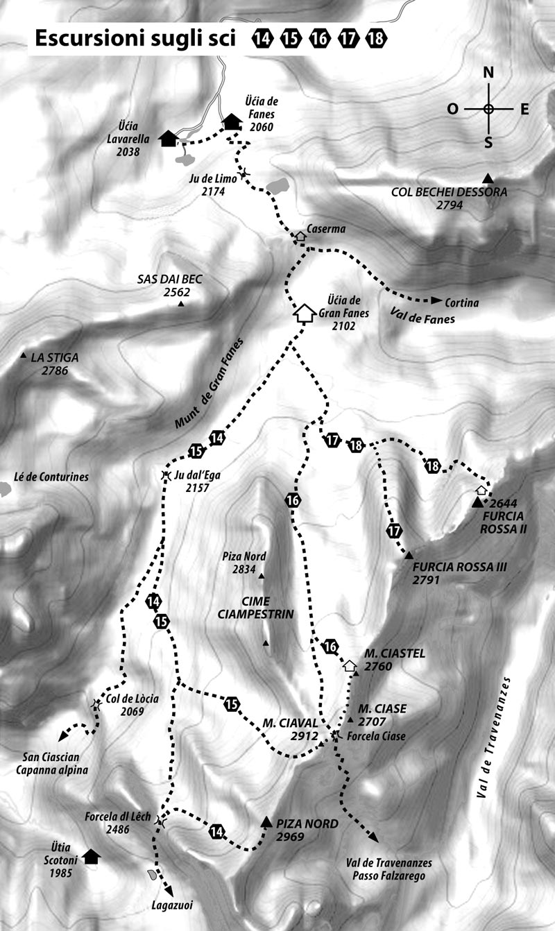
Tour 14: PIZA NORD – 2969 m – also »Punta Nord«
Tour 14: PIZA NORD – 2969 m – also »Punta Nord«
From the Fanes Mountain Hut towards Ju de Limo up to the Gran Fanes Mountain Hut. The head south-west for Ju dal Ega (Tadega pass) and then continue up to the crossroads on path number 20B towards Forcela dl Lêch. Before reaching the pass turn left and climb the side valley that leads to Forcela de Fanes (2926 m). From here cross the southern ridge up to the summit where skis can usually be left.
Duration: from 5½ to 7 hours • Difference in altitude: around 1100 m
Note: A demanding and long tour in a remote area. Good technique is required.
Easy
Tour 15: MONTE CIAVAL – 2912 m – from the west – also »Monte Cavallo«
Tour 15: MONTE CIAVAL – 2912 m – from the west – also »Monte Cavallo«
From the Fanes Mountain Hut passing through Ju de Limo up to the Gran Fanes Mountain Hut. Then head southwest towards Ju dal Ega (Tadega pass) and continue up to the crossroads on path number 20B towards Forcela dl Lêch. Climb towards the summer path for around 170 m, then turn southwest towards Valun de Ciampestrin. The last part which is very steep is difficult up to the small pass to the southwest of Monte Ciaval at 2862 m, where usually the ski storage is erected. The summit can be reached through the southwest ridge.
Duration: 4-6 hours • Difference in altitude: around 950 m
Note: A demanding tour in a remote area. Good technique is required.
Easy
Tour 16: MONTE CIASTEL – 2760 m – also »Monte Castello«
Tour 16: MONTE CIASTEL – 2760 m – also »Monte Castello«
From the Fanes Mountain Hut passing through Ju de Limo up to the Gran Fanes Mountain Hut (2102 m). Follow the valley for around 300 m to the south towards Tadega pass and then turn left (southeast). From the first opening proceed south along the path towards the wide upper valley of Valun Blanch, between Furcia Rossa III and Pizes de Ciampestrin (see summer Tour 7). Continue along the hills which is at first easy and then increasingly steeper until you reach a distinctive plateau. From here it is a good idea to keep right, cross the massive landslide (»Brotzeitfelsen« – »the old restaurant«) in a small valley directly under the protruding walls of Ciampestrin. Now descend along the ridge in the high part of Valun Blanch, through which you can reach the foot of Monte Ciastel and the small bivouac.
Duration: from 2½ to 3 hours • Difference in altitude: around 800 m
Note: Not a difficult tour. From Monte Ciastel you can also reach Monte Ciase (also »Monte Casale«, 2894 m) and Monte Ciaval (also »Monte Cavallo«, 2912 m) if conditions permit and with suitable material. In the majority of cases we recommend leaving your skis in the ski storage in Monte Ciastel.
Easy
Tour 17: PIZA DE FURCIA ROSSA III – 2791 m
Tour 17: PIZA DE FURCIA ROSSA III – 2791 m
From the Fanes Mountain Hut like Tour 16 up to Ju de Limo (2172 m), continuing up to Munt de Gran Fanes (2102 m). At around 300 m follow the valley towards Ju dal Ega and then turn left (southeast) in the first valley. From here follow summer path number 17 towards Monte Valon Bianco, until you reach the foot of Furcia Rossa III.
A steep gully that requires mountaineering climbing (in the summer with ropes), leads to the less steep crest of the mountain. The continue up the hairpin bend to another not so difficult rocky plane until you reach a slightly flatter shoulder. The summit can be reached by keeping right (beware of the rocky leaps underneath).
Duration: 3-4 hours • Difference in altitude: around 840 m
Note: The steep gully at the foot of the mountain is the key point of the tour. Here skis must be taken up and down. The ropes present in the summer are covered in snow. Difficulty depends strongly on the snow conditions. Technical climbing skills are required on mixed terrain. The shoulder is an avalanche risk.
Easy
Tour 18: PIZA DE FURCIA ROSSA II – 2703 m
Tour 18: PIZA DE FURCIA ROSSA II – 2703 m
From the Fanes Mountain Hut like Tour 17, up to the foot of Furcia Rossa III. Then keeping left under the wall of Furcia Rossa III head eastwards and then south eastwards climbing to the high valley between Furcia Rossa III and Furcia Rossa II. Follow the old war road that is more or less recognisable at the foot of Furcia Rossa II or continue left along the steep gully in the rocky valley between Furcia Rossa I and Furcia Rossa II. The summit can be reached by climbing this gully and passing over the rock barriers that lead to Bivacco Baborca or by climbing to the right.
Duration: 3-4 hours • Difference in altitude: around 750 m
Note: Only recommended in good snow coverage. The wide rocky valley that leads to Furcia Rossa II is an avalanche risk.
Easy
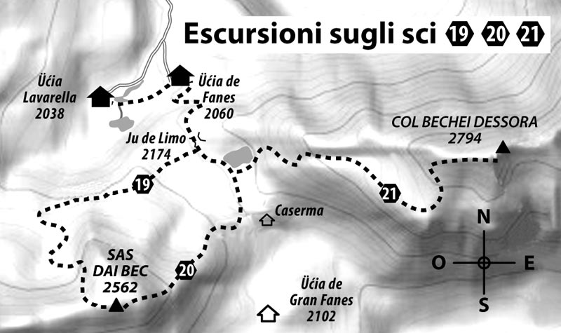
Tour 19: SAS DAI BEC – 2562 m – from the east
Tour 19: SAS DAI BEC – 2562 m – from the east
This ski tour appears to be brief and is often underestimated also in terms of avalanche risk.
From the Fanes Mountain Hut towards Ju de Limo up to the barracks. Then on the left of the eastern slope of Sas dai Bec towards the summit.
Duration: from 1½ to 2½ • Difference in altitude: around 500 m
Note: Only recommended in good snow conditions.
Easy
Tour 20: SAS DAI BEC – 2562 m – from the north
Tour 20: SAS DAI BEC – 2562 m – from the north
From the Fanes Mountain Hut towards Ju de Limo. On the plateau keep right (west) until you reach the northern slope of Sas dai Bec. Then turn south. The rock belt must be crossed at the easiest point removing your skis. At this point on easier terrain you can reach the summit.
Duration: from 1½ to 2½ • Difference in altitude: around 500 m
Note: Only recommended in good snow conditions.
Easy
Tour 21: COL BECHEI DESSORA 2794 m
Tour 21: COL BECHEI DESSORA 2794 m
From the Fanes Mountain Huts follow the road above Ju de Limo (2172 m) to reach frozen Lé de Limo. Here turn east initially with a few turns until you reach the not so steep and almost flat shoulder (2565 m, the old artillery base). Then go north with a series of hairpin bend until you reach the western ridge (beware of snow cornices). Following the contour of the ridge head eastwards to the summit.
Duration: 2-3 hours • Difference in altitude: around 850 m
Note: A moderately difficult tour on partially steep terrain. Crampons are highly recommended. In the event of an avalanche risk pay close attention along the southern walls under the western ridge of Bechei.